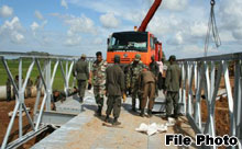
 TWO New roads, Trincomalee outer Circular Road and Seruwila-Somawathiya Road have been planned by the Road Development Authority (RDA) with the active participation of the Sri Lanka Army to improve connectivity between the Eastern and Northern Provinces with the rest of the country and facilitate an efficient road network for the economic development of the country.
The Trincomalee outer circular road will provide access to new areas identified around Trincomalee harbour for development to maximize land utilization. The road project is linking Nilaweli with Sampur in the environs of Trincomalee bay by connecting main arteries to Trincomalee city and provides the access to the proposed industrial zones declared by the Board of Investment (BOI) and Urban Development Authority (UDA).
The trace has been established by the Road Development Authority (RDA) along with the active participation of Sri Lanka Army (SLA).
An RDA spokesman said the opening up of new corridors and formation of road platform of the road has already started by the Army.
The road embankment of the Northern part of the road (AKT road junction to Pulmodai-Trincomalee road junction) has already been completed and the Southern part embankment from Sampur to Mahaweli river (Left bank side) is completed except the small section in Sampur side which has to be done with the construction of bridge across Mahaweli river.
The formation of road platform work from Mahaweli river to the Thampalakamam-Kinniya (B541) road has to be done.
There are eight major bridges including the bridge across Mahaweli river and 18 small bridges are located along the new alignment.
Seruwila-Somawathiya Road trace has been identified by the RDA with the help of the Army. The proposed road consists of several sections.
The proposed road trace starts at Southern end of Palatoppu-Seruwila (B347) road along the new alignment upto Arippu junction where it meets Batticaloa-Tirikondiyadimadu-Trincomalee (BTT) road (A015). The length of this section is approximately 6.7 km and the road platform has been completed.
From Arippu junction to Verugal river crossing (Batticaloa and Trincomalee district border) again road traverses along the new alignment. The length of this section is around 6.5 km and the trace has been cleared.
After the Verugal river crossing, it traverses through the jungle patch upto Kinnerikulam which also follows the new alignment of approximately 10 km in length. None of the activities has been carried out yet on this road stretch.
The road they traverse along the existing cart track from Kinnerikulam to Mattakkattikulam which has 6 km length.
The preparation of road platform of this section is in progress now under the supervision of the Army.
The next section is from Mattakkattikulam to Thrikonamadu and the formation of 10m wide road platform has been completed. The length of this section is around 1.5km. The section from Thrikonamadu to Sinhapura has a length of 8.2 km and traverses through the existing gravel road which is maintained by Mahaweli Authority. The platform width of this section is 10m.
The road section from Sinhapura to Kandakadu is on existing metal and tarred road maintained by the Mahaweli Authority.
The length of this section is 4.6 km and the carriageway width is 5m.
The next section from Kandakadu to Mahaweli river crossing traverse through the existing gravel road which belongs to the Mahaweli Authority.
The length of this section is around 5.9 km and the platform width of this section is approximately 8m.
The final section from Mahaweli river crossing to Somawathiya traverses through the new alignment of 2.5 km and the 10m wide platform has been completed on this section. The total length of the road is around 51.9 km.
There are four major bridges along the proposed trace which includes a major bridge across Mahaweli river which has a span of nearly 300m and others are Arippu, Verugal and Kandakadu with 30m. 85m and 50m spans respectively.
Project purpose
The main objective of the project is to improve connectivity to Eastern and Northern Provinces from the rest of the country.
The selected roads traverse through the rural areas which has agriculture based economy.
The improvement of roads will improve the accessibility to these economically backward areas.
The improvement of road infrastructure will enable the quick improvement of other infrastructure facilities such as electricity, water and sanitation, health, education etc. in these rural areas.
Due to the lack of maintenance during the last three decades, the travel time and vehicle operating cost have been increased. It is expected to reduce the vehicle operating cost and travel time with the road improvement.
(Courtesy : Daily News)

